Geolocate

Sukaraja topographic map

Click on the map to display elevation.

About this map

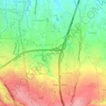
Name: Sukaraja topographic map, elevation, terrain.

Location: Sukaraja, Bogor, West Java, 16143, Indonesia (-6.61723 106.80912 -6.57723 106.84912)

Average elevation: 255 m

Minimum elevation: 196 m

Maximum elevation: 320 m

Other topographic maps

Click on a map to view its topography, its elevation and its terrain.

Bogor Selatan

Indonesia > West Java > Bogor

Average elevation: 377 m

Bogor Timur

Indonesia > West Java > Bogor

Average elevation: 329 m

Tanah Sareal

Indonesia > West Java > Bogor

Average elevation: 182 m

Tanah Sareal

Indonesia > West Java > Bogor

Average elevation: 215 m

Bogor Barat

Indonesia > West Java > Bogor

Average elevation: 215 m

Ciomas

Indonesia > West Java > Bogor

Average elevation: 230 m

Gear up for your next adventure:

🥤Collapsible Travel Cup - Saves space and weight in your mess kit
💧Collapsible Water Bottle - Space-saving water bottle for outdoor activities
🔥Camping Stove - Portable stoves to cook outdoors with ease
Family Camping Tent - Spacious tent suitable for family camping trips
🥾Hiking Shorts - Breathable shorts suitable for summer hikes

As an Amazon Associate, this site earns from qualifying purchases at no extra cost to you.