
Make a donation
Gear up for your next adventure:
As an Amazon Associate, this site earns from qualifying purchases at no extra cost to you.
Kalumunda Forest Reserve topographic map
Click on the map to display elevation.
Make a donation
Gear up for your next adventure:
As an Amazon Associate, this site earns from qualifying purchases at no extra cost to you.
About this map
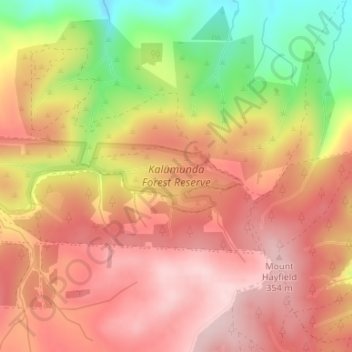
Name: Kalumunda Forest Reserve topographic map, elevation, terrain.
Average elevation: 265 m
Minimum elevation: 101 m
Maximum elevation: 364 m
Make a donation
Gear up for your next adventure:
As an Amazon Associate, this site earns from qualifying purchases at no extra cost to you.
Other topographic maps
Click on a map to view its topography, its elevation and its terrain.
Mount Hayfield
Australia > South Australia > The District Council of Yankalilla
Average elevation: 278 m
Inman Valley
Australia > South Australia > The District Council of Yankalilla
In the valley is Selwyn Rock (35°29′47″S 138°30′45″E / 35.4965°S 138.5124°E / -35.4965; 138.5124) a glaciated pavement in the bed of the Inman River. It was first described in 1859 by, and later named for, A.R.C. Selwyn, who was Victorian Government geologist at the time. Glacial grooves…
Average elevation: 212 m
Make a donation
Gear up for your next adventure:
As an Amazon Associate, this site earns from qualifying purchases at no extra cost to you.
Make a donation
Gear up for your next adventure:
As an Amazon Associate, this site earns from qualifying purchases at no extra cost to you.
Deep Creek National Park
Australia > South Australia > The District Council of Yankalilla
Average elevation: 183 m
Make a donation
Gear up for your next adventure:
As an Amazon Associate, this site earns from qualifying purchases at no extra cost to you.
Myponga Beach
Australia > South Australia > The District Council of Yankalilla
Average elevation: 110 m
Inman Valley
Australia > South Australia > The District Council of Yankalilla
In the valley is Selwyn Rock (35°29′47″S 138°30′45″E / 35.4965°S 138.5124°E / -35.4965; 138.5124) a glaciated pavement in the bed of the Inman River. It was first described in 1859 by, and later named for, A.R.C. Selwyn,[17] who was Victorian Government geologist at the time. Glacial…
Average elevation: 212 m
Make a donation
Gear up for your next adventure:
As an Amazon Associate, this site earns from qualifying purchases at no extra cost to you.