
Make a donation
Gear up for your next adventure:
As an Amazon Associate, this site earns from qualifying purchases at no extra cost to you.
Murdochville topographic map
Click on the map to display elevation.
Make a donation
Gear up for your next adventure:
As an Amazon Associate, this site earns from qualifying purchases at no extra cost to you.
Murdochville
Murdochville est une ville minière du Québec située dans la municipalité régionale de comté de La Côte-de-Gaspé dans la région administrative de la Gaspésie–Îles-de-la-Madeleine. Elle se trouve à 580 mètres d'altitude. La municipalité est membre de la Fédération des Villages-relais du Québec.
Make a donation
Gear up for your next adventure:
As an Amazon Associate, this site earns from qualifying purchases at no extra cost to you.
About this map
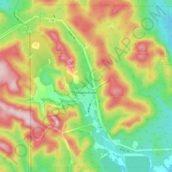
Name: Murdochville topographic map, elevation, terrain.
Average elevation: 665 m
Minimum elevation: 470 m
Maximum elevation: 908 m
Make a donation
Gear up for your next adventure:
As an Amazon Associate, this site earns from qualifying purchases at no extra cost to you.
Other topographic maps
Click on a map to view its topography, its elevation and its terrain.
Make a donation
Gear up for your next adventure:
As an Amazon Associate, this site earns from qualifying purchases at no extra cost to you.
L'Anse-au-Griffon-Nord
Canada > Québec > La Côte-de-Gaspé > Gaspé > L'Anse-au-Griffon
Average elevation: 42 m
Make a donation
Gear up for your next adventure:
As an Amazon Associate, this site earns from qualifying purchases at no extra cost to you.
Cap du Sud-Ouest
Canada > Québec > La Côte-de-Gaspé > Gaspé > Petite-Rivière-au-Renard
Average elevation: 45 m
Make a donation
Gear up for your next adventure:
As an Amazon Associate, this site earns from qualifying purchases at no extra cost to you.
Make a donation
Gear up for your next adventure:
As an Amazon Associate, this site earns from qualifying purchases at no extra cost to you.
Pointe à la Frégate
Canada > Québec > La Côte-de-Gaspé > Cloridorme > Pointe-à-la-Frégate
Average elevation: 44 m