
Make a donation
Gear up for your next adventure:
As an Amazon Associate, this site earns from qualifying purchases at no extra cost to you.
Jefferson Mount topographic map
Click on the map to display elevation.
Make a donation
Gear up for your next adventure:
As an Amazon Associate, this site earns from qualifying purchases at no extra cost to you.
About this map
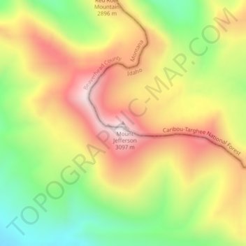
Name: Jefferson Mount topographic map, elevation, terrain.
Location: Jefferson Mount, Fremont County, Idaho, United States (44.56237 -111.50473 44.56247 -111.50463)
Average elevation: 2,767 m
Minimum elevation: 2,426 m
Maximum elevation: 3,098 m
Make a donation
Gear up for your next adventure:
As an Amazon Associate, this site earns from qualifying purchases at no extra cost to you.
Other topographic maps
Click on a map to view its topography, its elevation and its terrain.
Newdale
United States > Idaho > Fremont County
Newdale is the nearest city to the Teton Dam, which failed on June 5, 1976. Newdale did not receive any flooding or damage, due to its elevation and position relative to the dam.
Average elevation: 1,550 m
Make a donation
Gear up for your next adventure:
As an Amazon Associate, this site earns from qualifying purchases at no extra cost to you.
American Legion / Daughters of Utah Pioneers Park
United States > Idaho > Fremont County > St. Anthony
Average elevation: 1,515 m