Geolocate

Taxco topographic map

Click on the map to display elevation.

About this map

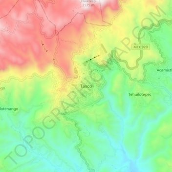
Name: Taxco topographic map, elevation, terrain.

Location: Taxco, Taxco de Alarcón, Guerrero, 40200, Mexico (18.51654 -99.64528 18.59654 -99.56528)

Average elevation: 1,792 m

Minimum elevation: 1,297 m

Maximum elevation: 2,551 m

Gear up for your next adventure:

🧢Outdoor Visor - Breathable visor for sunny hikes
🥾Mountain Hiking Shoes - Shoes with superior grip for mountainous terrain
🥾Trekking Boots - Durable boots for long-distance trekking
🔪Outdoor Multitool - Versatile tool for repairs and food prep in the wild
💡Portable Camping Lamp - Rechargeable lamp for campsite lighting

As an Amazon Associate, this site earns from qualifying purchases at no extra cost to you.