Geolocate

Reggio Calabria topographic map

Click on the map to display elevation.

About this map
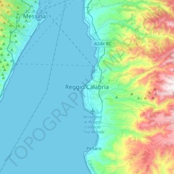
Name: Reggio Calabria topographic map, elevation, terrain.

Location: Reggio Calabria, Calabria, Italy (37.99182 15.63023 38.21412 15.86504)

Average elevation: 224 m

Minimum elevation: 0 m

Maximum elevation: 1,187 m

Other topographic maps

Click on a map to view its topography, its elevation and its terrain.
Saline Joniche

Italy > Calabria > Reggio Calabria

Average elevation: 58 m

Gambarie

Italy > Calabria > Reggio Calabria

Average elevation: 1,305 m

Monasterace Marina

Italy > Calabria > Reggio Calabria

Average elevation: 19 m

Gear up for your next adventure:

⛺Family Camping Tent - Spacious tent suitable for family camping trips
🚲MTB Frame Bag - Carry tools and maps directly on your bicycle frame
🌡️Emergency Mylar Blankets - Compact thermal protection for unexpected nights outdoors
🔨Vehicle Emergency Tool - Safety tool for remote road trips to trailheads
🧥Softshell Jacket - Windproof and breathable jacket for hiking

As an Amazon Associate, this site earns from qualifying purchases at no extra cost to you.