Geolocate

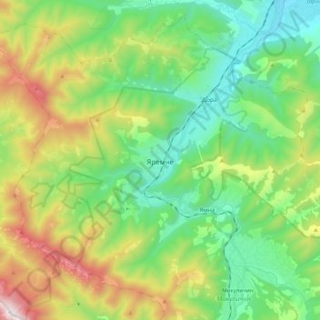
Yaremche topographic map

Click on the map to display elevation.

Yaremche

Yaremche (Ukrainian: Яремче, IPA: [jɐˈrɛmtʃe] ; Polish: Jaremcze or Jaremcza) is a town in Nadvirna Raion, Ivano-Frankivsk Oblast (province) of west Ukraine. The Town is located at the altitude of around 580 metres (1,900 ft) above mean sea level. Yaremche hosts the administration of Yaremche urban hromada, one of the hromadas of Ukraine. Population: 7,907 (2022 estimate).

Wikipedia (CC-BY-SA 3.0)

About this map

Name: Yaremche topographic map, elevation, terrain.

Location: Yaremche, Yaremche Urban Hromada, Nadvirna Raion, Ivano-Frankivsk Oblast, Ukraine (48.39072 24.44375 48.51117 24.64323)

Average elevation: 819 m

Minimum elevation: 420 m

Maximum elevation: 1,659 m

Gear up for your next adventure:

🧤Thermal Hiking Gloves - Grip-enhanced gloves for cold-weather altitude trekking
🧢Hiking Hat - Sun-protective and breathable hats for long treks
🧊Portable Cooler - Keep food and drinks cold during outdoor adventures
🥫Freeze-Dried Meals - Lightweight, high-calorie nutrition for multi-day treks
🥾Light Trekking Boots - Supportive boots for multi-day treks

As an Amazon Associate, this site earns from qualifying purchases at no extra cost to you.