
Make a donation
Gear up for your next adventure:
As an Amazon Associate, this site earns from qualifying purchases at no extra cost to you.
Bristol topographic map
Click on the map to display elevation.
Make a donation
Gear up for your next adventure:
As an Amazon Associate, this site earns from qualifying purchases at no extra cost to you.
Bristol
According to the United States Census Bureau, the town has a total area of 21.9 square miles (56.8 km2), of which 16.8 square miles (43.4 km2) are land and 5.2 square miles (13.4 km2) are water, comprising 23.60% of the town. Bristol is drained by the Pemigewasset River (forming the southeastern boundary of the town), the Smith River (on the town's short southern boundary) and the Newfound River, draining Newfound Lake and most of the center of town. The highest point in town is Bristol Peak, elevation 1,803 feet (550 m) above sea level. Bristol lies fully within the Merrimack River watershed.
Make a donation
Gear up for your next adventure:
As an Amazon Associate, this site earns from qualifying purchases at no extra cost to you.
About this map
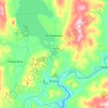
Name: Bristol topographic map, elevation, terrain.
Location: Bristol, Grafton County, New Hampshire, 03222, United States (43.56344 -71.79255 43.67518 -71.65108)
Average elevation: 254 m
Minimum elevation: 95 m
Maximum elevation: 580 m
Make a donation
Gear up for your next adventure:
As an Amazon Associate, this site earns from qualifying purchases at no extra cost to you.
Other topographic maps
Click on a map to view its topography, its elevation and its terrain.
Streeter Mountain
United States > New Hampshire > Grafton County > Dorchester
Average elevation: 449 m
Make a donation
Gear up for your next adventure:
As an Amazon Associate, this site earns from qualifying purchases at no extra cost to you.
Make a donation
Gear up for your next adventure:
As an Amazon Associate, this site earns from qualifying purchases at no extra cost to you.
The Village of Loon Mountain
United States > New Hampshire > Grafton County > Lincoln
Average elevation: 532 m
Make a donation
Gear up for your next adventure:
As an Amazon Associate, this site earns from qualifying purchases at no extra cost to you.
Make a donation
Gear up for your next adventure:
As an Amazon Associate, this site earns from qualifying purchases at no extra cost to you.
Make a donation
Gear up for your next adventure:
As an Amazon Associate, this site earns from qualifying purchases at no extra cost to you.
Stinson Lake
United States > New Hampshire > Grafton County > Rumney > Stinson Lake
Average elevation: 460 m
Make a donation
Gear up for your next adventure:
As an Amazon Associate, this site earns from qualifying purchases at no extra cost to you.
Mount Kineo, East Peak
United States > New Hampshire > Grafton County > Ellsworth
Average elevation: 710 m
LeBruns Mobile Home Park
United States > New Hampshire > Grafton County > Lebanon > LeBruns Mobile Home Park
Average elevation: 326 m
West Lebanon
United States > New Hampshire > Grafton County > Lebanon > West Lebanon
Average elevation: 165 m
Make a donation
Gear up for your next adventure:
As an Amazon Associate, this site earns from qualifying purchases at no extra cost to you.
North Littleton
United States > New Hampshire > Grafton County > Littleton > North Littleton
Average elevation: 333 m