
Thank you for supporting this site ❤️
Make a donation
Make a donation
Gear up for your next adventure:
As an Amazon Associate, this site earns from qualifying purchases at no extra cost to you.
Pardeeville topographic map
Click on the map to display elevation.
Thank you for supporting this site ❤️
Make a donation
Make a donation
Gear up for your next adventure:
As an Amazon Associate, this site earns from qualifying purchases at no extra cost to you.
About this map
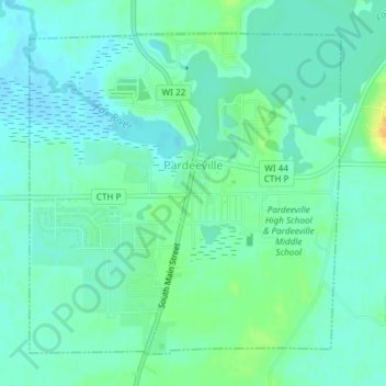
Name: Pardeeville topographic map, elevation, terrain.
Location: Pardeeville, Columbia County, Wisconsin, United States (43.52451 -89.31594 43.54698 -89.28587)
Average elevation: 249 m
Minimum elevation: 240 m
Maximum elevation: 269 m
Thank you for supporting this site ❤️
Make a donation
Make a donation
Gear up for your next adventure:
As an Amazon Associate, this site earns from qualifying purchases at no extra cost to you.
Other topographic maps
Click on a map to view its topography, its elevation and its terrain.
Englewood
United States > Wisconsin > Columbia County > Town of Fountain Prairie
Average elevation: 276 m