Geolocate

Columbia topographic map

Interactive map

Click on the map to display elevation.

About this map

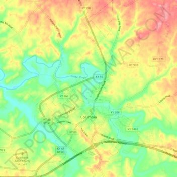
Name: Columbia topographic map, elevation, terrain.

Location: Columbia, Adair County, Kentucky, 42728, United States (37.07337 -85.33907 37.16016 -85.27944)

Average elevation: 241 m

Minimum elevation: 191 m

Maximum elevation: 298 m

Other topographic maps

Click on a map to view its topography, its elevation and its terrain.

Cane Valley

United States > Kentucky > Adair County

Cane Valley, Adair County, Kentucky, United States

Average elevation: 255 m

Flatwood

United States > Kentucky > Adair County

Flatwood, Adair County, Kentucky, United States

Average elevation: 252 m

Barnett Springs

United States > Kentucky > Adair County

Barnett Springs, Adair County, Kentucky, United States

Average elevation: 285 m

Pickett

United States > Kentucky > Adair County > Pickett

Pickett, Adair County, Kentucky, 42742, United States

Average elevation: 224 m

Chance

United States > Kentucky > Adair County > Chance

Chance, Adair County, Kentucky, United States

Average elevation: 276 m

Breeding

United States > Kentucky > Adair County

Breeding, Adair County, Kentucky, United States

Average elevation: 302 m