
Letenye topographic map
Interactive map
Click on the map to display elevation.
About this map
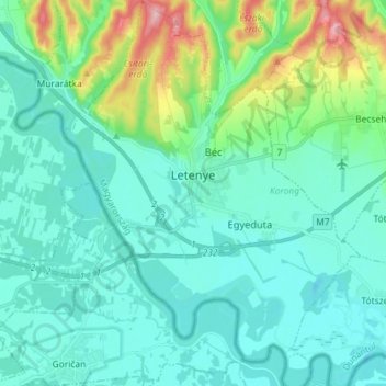
Name: Letenye topographic map, elevation, terrain.
Location: Letenye, Letenyei járás, Zala, Transdanubia, 8868, Hungary (46.37764 16.67439 46.47784 16.78574)
Average elevation: 165 m
Minimum elevation: 130 m
Maximum elevation: 319 m
Other topographic maps
Click on a map to view its topography, its elevation and its terrain.