Geolocate

Alto do Couso topographic map

Click on the map to display elevation.

About this map

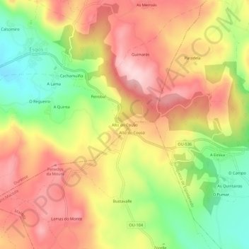
Name: Alto do Couso topographic map, elevation, terrain.

Location: Alto do Couso, Ourense, Galicia, 32720, España (42.29317 -7.69681 42.33317 -7.65681)

Average elevation: 679 m

Minimum elevation: 538 m

Maximum elevation: 795 m

Gear up for your next adventure:

🧥Softshell Jacket - Windproof and breathable jacket for hiking
🧰Emergency Multi-Tool - Compact multi-tool for outdoor survival
Bushcraft Tarp - Versatile emergency shelter or gear protection
🦌Outdoor Trail Camera - Monitor wildlife activity near your favorite spots
🥾Approach Boots - Comfortable boots for hiking and climbing approaches

As an Amazon Associate, this site earns from qualifying purchases at no extra cost to you.