
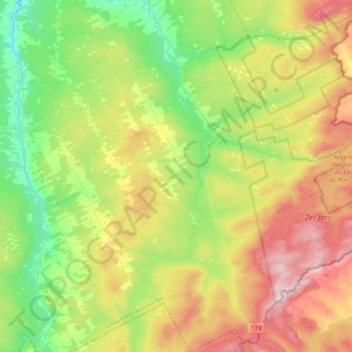
Saint-Théophile topographic map
Interactive map
Click on the map to display elevation.
About this map
Name: Saint-Théophile topographic map, elevation, terrain.
Average elevation: 413 m
Minimum elevation: 193 m
Maximum elevation: 769 m
Other topographic maps
Click on a map to view its topography, its elevation and its terrain.
Lac Douville
Canada > Quebec > Beauce-Sartigan > Saint-Georges
Lac Douville, Saint-Georges, Beauce-Sartigan, Chaudière-Appalaches, Quebec, Canada
Average elevation: 320 m
La Guadeloupe
Canada > Quebec > Beauce-Sartigan
La Guadeloupe, Beauce-Sartigan, Chaudière-Appalaches, Quebec, G0M 1G0, Canada
Average elevation: 329 m
Saint-Georges
Canada > Quebec > Beauce-Sartigan
Saint-Georges, Beauce-Sartigan, Chaudière-Appalaches, Quebec, Canada
Average elevation: 296 m