Geolocate

Colico topographic map

Click on the map to display elevation.

About this map

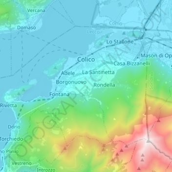
Name: Colico topographic map, elevation, terrain.

Location: Colico, Lecco, Lombardy, 23823, Italy (46.09237 9.29262 46.15172 9.41538)

Average elevation: 452 m

Minimum elevation: 189 m

Maximum elevation: 1,682 m

Other topographic maps

Click on a map to view its topography, its elevation and its terrain.

i Noc

Italy > Lombardy > Lecco > Dorio

Average elevation: 557 m

Gear up for your next adventure:

🧶550 Survival Paracord - Versatile utility cord for emergency repairs and rigging
🥾Trail Hiking Shoes - Durable shoes designed for rugged trails
🥾Trail Hiking Boots - Supportive boots for rough trails
🧢Outdoor Cap - Protective cap for sun and rain during hikes
🔪Outdoor Multitool - Versatile tool for repairs and food prep in the wild

As an Amazon Associate, this site earns from qualifying purchases at no extra cost to you.