
Thank you for supporting this site ❤️
Make a donation
Make a donation
Gear up for your next adventure:
As an Amazon Associate, this site earns from qualifying purchases at no extra cost to you.
Pinnow topographic map
Click on the map to display elevation.
Thank you for supporting this site ❤️
Make a donation
Make a donation
Gear up for your next adventure:
As an Amazon Associate, this site earns from qualifying purchases at no extra cost to you.
About this map
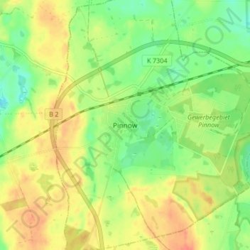
Name: Pinnow topographic map, elevation, terrain.
Location: Pinnow, Schwedt/Oder, Uckermark, Brandenburg, Deutschland (53.04044 14.06553 53.08044 14.10553)
Average elevation: 49 m
Minimum elevation: 28 m
Maximum elevation: 69 m
Thank you for supporting this site ❤️
Make a donation
Make a donation
Gear up for your next adventure:
As an Amazon Associate, this site earns from qualifying purchases at no extra cost to you.