Geolocate

Butteville topographic map

Click on the map to display elevation.

About this map

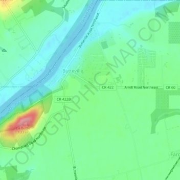
Name: Butteville topographic map, elevation, terrain.

Location: Butteville, Marion County, Oregon, United States (45.24416 -122.84971 45.27405 -122.82470)

Average elevation: 53 m

Minimum elevation: 23 m

Maximum elevation: 132 m

Gear up for your next adventure:

🛶Canoe Life Vest - Safety vest for water sports
🚲Heavy Duty Bike Lock - Secure your bike at the trailhead or during stops
🧰Multitool Knife - Compact and versatile tool for outdoor use
🧥Insulated Jacket - Keep warm in cold outdoor conditions
🪑Ultralight Camping Stool - Compact seating for rest stops during long hikes

As an Amazon Associate, this site earns from qualifying purchases at no extra cost to you.