
Thank you for supporting this site ❤️
Make a donation
Make a donation
Gear up for your next adventure:
As an Amazon Associate, this site earns from qualifying purchases at no extra cost to you.
Bleche topographic map
Click on the map to display elevation.
Thank you for supporting this site ❤️
Make a donation
Make a donation
Gear up for your next adventure:
As an Amazon Associate, this site earns from qualifying purchases at no extra cost to you.
About this map
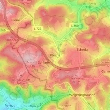
Name: Bleche topographic map, elevation, terrain.
Location: Bleche, Drolshagen, Kreis Olpe, Nordrhein-Westfalen, Deutschland (51.03959 7.70648 51.07959 7.74648)
Average elevation: 431 m
Minimum elevation: 286 m
Maximum elevation: 520 m
Thank you for supporting this site ❤️
Make a donation
Make a donation
Gear up for your next adventure:
As an Amazon Associate, this site earns from qualifying purchases at no extra cost to you.