Geolocate

Pendshet topographic map

Click on the map to display elevation.

About this map

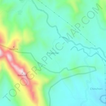
Name: Pendshet topographic map, elevation, terrain.

Location: Pendshet, Akola, Ahmednagar, Maharashtra, India (19.57267 73.72294 19.61267 73.76294)

Average elevation: 873 m

Minimum elevation: 713 m

Maximum elevation: 1,327 m

Other topographic maps

Click on a map to view its topography, its elevation and its terrain.

Babhulgaon

India > Maharashtra > Akola > Babhulgaon

Average elevation: 294 m

Borgaon Manju

India > Maharashtra > Akola

Average elevation: 295 m

Dongargaon

India > Maharashtra > Akola > Dongargaon

Average elevation: 294 m

Pahadpur

India > Maharashtra > Akola

Average elevation: 299 m

Nizampur

India > Maharashtra > Akola

Average elevation: 280 m

Nawakheda

India > Maharashtra > Akola

Average elevation: 270 m

Hingna Barling

India > Maharashtra > Akola

Average elevation: 286 m

Kothari

India > Maharashtra > Akola

Average elevation: 299 m

Gear up for your next adventure:

🔭Outdoor Binoculars - Lightweight binoculars for birdwatching and hiking
🥾Mountain Trail Shoes - High-traction shoes for mountain trails
🥾Waterproof Hiking Shoes - Durable shoes for wet and rugged trails
🧤Rechargeable Heated Gloves - Extreme warmth for Canadian winter expeditions
🥾Mountaineering Boots - Supportive boots for climbing and high-altitude hiking

As an Amazon Associate, this site earns from qualifying purchases at no extra cost to you.