Geolocate

Tidmarsh topographic map

Click on the map to display elevation.

About this map

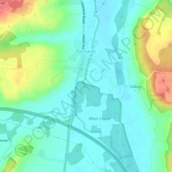
Name: Tidmarsh topographic map, elevation, terrain.

Location: Tidmarsh, West Berkshire, England, United Kingdom (51.45059 -1.11394 51.47680 -1.07656)

Average elevation: 60 m

Minimum elevation: 40 m

Maximum elevation: 110 m

Other topographic maps

Click on a map to view its topography, its elevation and its terrain.

Mortimer

United Kingdom > England > West Berkshire > Mortimer

Average elevation: 80 m

Gear up for your next adventure:

🧭GPS Handheld Device - Reliable GPS navigation for outdoor adventures
🥾Trail Hiking Boots - Supportive boots for rough trails
🧤Rechargeable Heated Gloves - Extreme warmth for Canadian winter expeditions
🔋Lithium AA Batteries - Long-lasting power that performs in extreme cold
🔦LED Flashlight - Powerful and long-lasting flashlight for camping and emergencies

As an Amazon Associate, this site earns from qualifying purchases at no extra cost to you.