
Make a donation
Gear up for your next adventure:
As an Amazon Associate, this site earns from qualifying purchases at no extra cost to you.
Parkstein topographic map
Click on the map to display elevation.
Make a donation
Gear up for your next adventure:
As an Amazon Associate, this site earns from qualifying purchases at no extra cost to you.
About this map
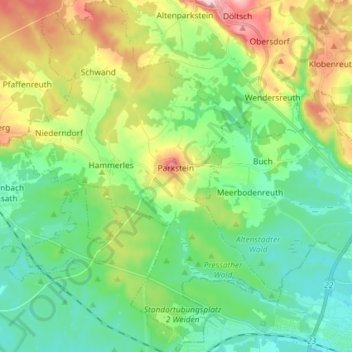
Name: Parkstein topographic map, elevation, terrain.
Average elevation: 456 m
Minimum elevation: 393 m
Maximum elevation: 593 m
Make a donation
Gear up for your next adventure:
As an Amazon Associate, this site earns from qualifying purchases at no extra cost to you.
Other topographic maps
Click on a map to view its topography, its elevation and its terrain.
Stockweiher
Deutschland > Bayern > Landkreis Neustadt an der Waldnaab > Kirchenthumbach > Metzenhof
Average elevation: 446 m
Make a donation
Gear up for your next adventure:
As an Amazon Associate, this site earns from qualifying purchases at no extra cost to you.
Niederland
Deutschland > Bayern > Landkreis Neustadt an der Waldnaab > Saubersrieth
Average elevation: 558 m
Putzenrieth
Deutschland > Bayern > Landkreis Neustadt an der Waldnaab > Eslarn
Average elevation: 538 m
Make a donation
Gear up for your next adventure:
As an Amazon Associate, this site earns from qualifying purchases at no extra cost to you.
Teufelstein
Deutschland > Bayern > Landkreis Neustadt an der Waldnaab > Eslarn
Average elevation: 547 m
Fahrenberg
Deutschland > Bayern > Landkreis Neustadt an der Waldnaab > Waldthurn
Average elevation: 668 m
Eichelberg
Deutschland > Bayern > Landkreis Neustadt an der Waldnaab > Pressath
Average elevation: 462 m
Make a donation
Gear up for your next adventure:
As an Amazon Associate, this site earns from qualifying purchases at no extra cost to you.
Kaimling
Deutschland > Bayern > Landkreis Neustadt an der Waldnaab > Vohenstrauß > Kaimling
Average elevation: 510 m
Achberg
Deutschland > Bayern > Landkreis Neustadt an der Waldnaab > Luhe-Wildenau
Average elevation: 461 m
Oberfahrenberg
Deutschland > Bayern > Landkreis Neustadt an der Waldnaab > Waldthurn
Average elevation: 630 m
Make a donation
Gear up for your next adventure:
As an Amazon Associate, this site earns from qualifying purchases at no extra cost to you.
Artesgrün
Deutschland > Bayern > Landkreis Neustadt an der Waldnaab > Kohlberg
Average elevation: 476 m
Make a donation
Gear up for your next adventure:
As an Amazon Associate, this site earns from qualifying purchases at no extra cost to you.
Thurndorf
Deutschland > Bayern > Landkreis Neustadt an der Waldnaab
Wegen Platzmangels am alten Thurndorfer Friedhof sah sich der Pfarrgemeinderat in der Pflicht, den Friedhof erweitern zu lassen. Als ein landwirtschaftliches Anwesen neben dem alten Friedhof 1998 abgerissen wurde, kamen Reste der Burg Thurndorf zum Vorschein. Der Turmstumpf mit seinen über drei Meter dicken…
Average elevation: 563 m
Friedersreuth
Deutschland > Bayern > Landkreis Neustadt an der Waldnaab > Pressath
Average elevation: 548 m
Make a donation
Gear up for your next adventure:
As an Amazon Associate, this site earns from qualifying purchases at no extra cost to you.
Matzlesberg
Deutschland > Bayern > Landkreis Neustadt an der Waldnaab > Engleshof
Average elevation: 453 m
Roggenstein
Deutschland > Bayern > Landkreis Neustadt an der Waldnaab > Vohenstrauß
Average elevation: 527 m
Make a donation
Gear up for your next adventure:
As an Amazon Associate, this site earns from qualifying purchases at no extra cost to you.
Döllnitz
Deutschland > Bayern > Landkreis Neustadt an der Waldnaab > Pressath
Average elevation: 475 m
Oberbernrieth
Deutschland > Bayern > Landkreis Neustadt an der Waldnaab > Waldthurn
Average elevation: 631 m
Make a donation
Gear up for your next adventure:
As an Amazon Associate, this site earns from qualifying purchases at no extra cost to you.
Altentreswitz
Deutschland > Bayern > Landkreis Neustadt an der Waldnaab > Vohenstrauß > Böhmischbruck
Average elevation: 534 m
Make a donation
Gear up for your next adventure:
As an Amazon Associate, this site earns from qualifying purchases at no extra cost to you.
Burgtreswitz
Deutschland > Bayern > Landkreis Neustadt an der Waldnaab
Die Lichtenstern-Pfleger brachten Treswitz im 18. Jahrhundert einen großen Aufschwung mit der Schaffung eines Landgerichts als Höhepunkt. Der Einzugsbereich erfasste die Orte Vohenstrauß, Moosbach, Pleystein, Eslarn, Waidhaus, Tännesberg, Waldthurn und Leuchtenberg. 1809 wurde das nahegelegene Vohenstrauß…
Average elevation: 518 m
Spielhof
Deutschland > Bayern > Landkreis Neustadt an der Waldnaab > Pleystein
Average elevation: 536 m
Letzau
Deutschland > Bayern > Landkreis Neustadt an der Waldnaab
Im 9. und 10. Jahrhundert entstanden die sogenannten Königstraßen oder Hochstraßen, die abseits der Flüsse über die Höhenzüge führten. Zu diesen gehörte die Letzauer Hochstraße, die von Anton Dollacker und Michel Hardt beschrieben wird. Sie führte von Amberg über Schnaittenbach, Luhe, Letzau, Floß…
Average elevation: 569 m
Löhlbach
Deutschland > Bayern > Landkreis Neustadt an der Waldnaab > Vohenstrauß > Untertresenfeld
Average elevation: 535 m
Make a donation
Gear up for your next adventure:
As an Amazon Associate, this site earns from qualifying purchases at no extra cost to you.
Kotzau
Deutschland > Bayern > Landkreis Neustadt an der Waldnaab > Meerbodenreuth > Kotzau
Average elevation: 449 m
Eslarn
Deutschland > Bayern > Landkreis Neustadt an der Waldnaab > Eslarn > Eslarn
Average elevation: 549 m
Hammerharlesberg
Deutschland > Bayern > Landkreis Neustadt an der Waldnaab > Hammerharlesberg
Average elevation: 434 m
Reinhardsrieth
Deutschland > Bayern > Landkreis Neustadt an der Waldnaab > Reinhardsrieth
Average elevation: 657 m
Make a donation
Gear up for your next adventure:
As an Amazon Associate, this site earns from qualifying purchases at no extra cost to you.
Kaimling
Deutschland > Bayern > Landkreis Neustadt an der Waldnaab > Vohenstrauß
Average elevation: 510 m