Geolocate

Laza topographic map

Click on the map to display elevation.

About this map

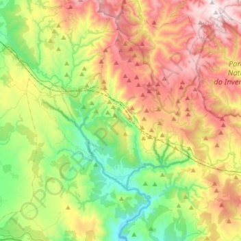
Name: Laza topographic map, elevation, terrain.

Location: Laza, Verín, Ourense, Galicia, Spain (42.00912 -7.56399 42.20405 -7.35087)

Average elevation: 937 m

Minimum elevation: 414 m

Maximum elevation: 1,701 m

Other topographic maps

Click on a map to view its topography, its elevation and its terrain.

As Vendas da Barreira

Spain > Galicia > Verín > Riós

Average elevation: 802 m

San Pedro de Trasverea

Spain > Galicia > Verín > Riós

Average elevation: 894 m

Gear up for your next adventure:

🥾Lightweight Hiking Shoes - Comfortable shoes for day hikes
💧Hydration Bladder - Hands-free hydration solution for long treks
🧢Sun Protection Cap - Breathable cap to protect from sun exposure
💧Reusable Water Bottle - Durable water bottles for hydration on trails
🧢Outdoor Cap - Protective cap for sun and rain during hikes

As an Amazon Associate, this site earns from qualifying purchases at no extra cost to you.