
Make a donation
Gear up for your next adventure:
As an Amazon Associate, this site earns from qualifying purchases at no extra cost to you.
Indiana County topographic map
Click on the map to display elevation.
Make a donation
Gear up for your next adventure:
As an Amazon Associate, this site earns from qualifying purchases at no extra cost to you.
About this map
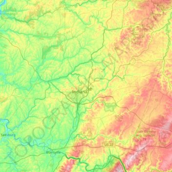
Name: Indiana County topographic map, elevation, terrain.
Location: Indiana County, Pennsylvania, United States (40.36868 -79.45964 40.91135 -78.79922)
Average elevation: 439 m
Minimum elevation: 239 m
Maximum elevation: 817 m
Make a donation
Gear up for your next adventure:
As an Amazon Associate, this site earns from qualifying purchases at no extra cost to you.
Other topographic maps
Click on a map to view its topography, its elevation and its terrain.
Feasterville
United States > Pennsylvania > Bucks County > Lower Southampton Township
Average elevation: 66 m
Saint Clair
United States > Pennsylvania > Westmoreland County > Hempfield Township
Average elevation: 333 m
Elkins Park Gardens
United States > Pennsylvania > Montgomery County > Cheltenham Township > Cheltenham
Average elevation: 70 m
Make a donation
Gear up for your next adventure:
As an Amazon Associate, this site earns from qualifying purchases at no extra cost to you.
Bala Cynwyd
United States > Pennsylvania > Montgomery County > Lower Merion Township
Average elevation: 75 m
Dalmatia
United States > Pennsylvania > Northumberland County > Lower Mahanoy Township
Average elevation: 172 m
Make a donation
Gear up for your next adventure:
As an Amazon Associate, this site earns from qualifying purchases at no extra cost to you.
Hemlock Farms
United States > Pennsylvania > Pike County > Blooming Grove Township
Average elevation: 437 m
Beaver Creek Dam
United States > Pennsylvania > Chester County > West Whiteland Township
Average elevation: 139 m
Make a donation
Gear up for your next adventure:
As an Amazon Associate, this site earns from qualifying purchases at no extra cost to you.
Make a donation
Gear up for your next adventure:
As an Amazon Associate, this site earns from qualifying purchases at no extra cost to you.
Airville
United States > Pennsylvania > York County > Lower Chanceford Township > Airville
Average elevation: 209 m
Point View
United States > Pennsylvania > Blair County > Catharine Township > Point View
Average elevation: 372 m
Philadelphia
United States > Pennsylvania > Philadelphia County > Philadelphia
Average elevation: 35 m
East End
United States > Pennsylvania > Centre County > Bellefonte > East End
Average elevation: 303 m
Make a donation
Gear up for your next adventure:
As an Amazon Associate, this site earns from qualifying purchases at no extra cost to you.
Remeos Mobile Home Park
United States > Pennsylvania > York County > Fairview Township
Average elevation: 133 m