Geolocate

Omkareshwar topographic map

Click on the map to display elevation.

About this map

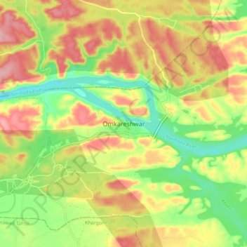
Name: Omkareshwar topographic map, elevation, terrain.

Location: Omkareshwar, Punasa Tahsil, Khandwa, Madhya Pradesh, India (22.20298 76.10957 22.28298 76.18957)

Average elevation: 216 m

Minimum elevation: 147 m

Maximum elevation: 284 m

Other topographic maps

Click on a map to view its topography, its elevation and its terrain.

Indira Sagar

India > Madhya Pradesh > Punasa Tahsil

Average elevation: 253 m

Mortakka

India > Madhya Pradesh > Punasa Tahsil

Average elevation: 183 m

Mandhata

India > Madhya Pradesh > Punasa Tahsil > Omkareshwar

Average elevation: 206 m

Chandel

India > Madhya Pradesh > Punasa Tahsil

Average elevation: 272 m

Gear up for your next adventure:

🔦LED Headlamp - Hands-free lighting for early morning starts or late finishes
🥾Trail Running Shoes - Lightweight and durable shoes for trail running
🥾Trekking Boots - Durable boots for long-distance trekking
📷Outdoor Action Camera - Capture high-elevation views and rugged adventures
🧢Beanie Hat - Keep your head warm in cold weather

As an Amazon Associate, this site earns from qualifying purchases at no extra cost to you.