
Make a donation
Gear up for your next adventure:
As an Amazon Associate, this site earns from qualifying purchases at no extra cost to you.
Slope County topographic map
Click on the map to display elevation.
Make a donation
Gear up for your next adventure:
As an Amazon Associate, this site earns from qualifying purchases at no extra cost to you.
Slope County
White Butte, the highest natural point in North Dakota at an elevation of 3,506 ft (1,069 m), is in southeast Slope County.
Make a donation
Gear up for your next adventure:
As an Amazon Associate, this site earns from qualifying purchases at no extra cost to you.
About this map
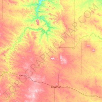
Name: Slope County topographic map, elevation, terrain.
Location: Slope County, North Dakota, United States (46.27931 -104.04610 46.63102 -102.92453)
Average elevation: 860 m
Minimum elevation: 700 m
Maximum elevation: 1,049 m
Make a donation
Gear up for your next adventure:
As an Amazon Associate, this site earns from qualifying purchases at no extra cost to you.
Other topographic maps
Click on a map to view its topography, its elevation and its terrain.
Bismarck Conservation and Outdoor Skills Area
United States > North Dakota > Burleigh County > Bismarck
Average elevation: 513 m
Make a donation
Gear up for your next adventure:
As an Amazon Associate, this site earns from qualifying purchases at no extra cost to you.
Turtle Mountain State Recreational Forest
United States > North Dakota > Bottineau County
Average elevation: 636 m
Make a donation
Gear up for your next adventure:
As an Amazon Associate, this site earns from qualifying purchases at no extra cost to you.
Antelope Creek State Wildlife Management Area
United States > North Dakota > McKenzie County
Average elevation: 573 m
North Salt Lake State Game Management Area
United States > North Dakota > Walsh County
Average elevation: 251 m
Make a donation
Gear up for your next adventure:
As an Amazon Associate, this site earns from qualifying purchases at no extra cost to you.
Make a donation
Gear up for your next adventure:
As an Amazon Associate, this site earns from qualifying purchases at no extra cost to you.
Make a donation
Gear up for your next adventure:
As an Amazon Associate, this site earns from qualifying purchases at no extra cost to you.
Make a donation
Gear up for your next adventure:
As an Amazon Associate, this site earns from qualifying purchases at no extra cost to you.