Geolocate

Nord topographic map

Click on the map to display elevation.

About this map
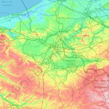
Name: Nord topographic map, elevation, terrain.

Location: Nord, Hauts-de-France, Metropolitan France, France (49.96892 2.07910 51.08899 4.23119)

Average elevation: 67 m

Minimum elevation: -4 m

Maximum elevation: 271 m

Other topographic maps

Click on a map to view its topography, its elevation and its terrain.
Amiens

France > Hauts-de-France > Somme > Amiens

Average elevation: 86 m

Arenberg

France > Hauts-de-France > Nord > Wallers

Average elevation: 31 m

Monchaux

France > Hauts-de-France > Somme > Quend

Average elevation: 6 m

Mouvaux

France > Hauts-de-France > Nord > Mouvaux > Mouvaux

Average elevation: 35 m

Mont du Tremble

France > Hauts-de-France > Oise > Compiègne

Average elevation: 58 m

Gear up for your next adventure:

💡Portable Camping Lamp - Rechargeable lamp for campsite lighting
🔭Compact Monocular - One-handed bird watching and trail spotting
🧢Hiking Sun Hat - Wide-brimmed protection for exposed mountain ridges
⛺Backpacking Tent - Lightweight tent for long-distance hiking trips
🔪Outdoor Multitool - Versatile tool for repairs and food prep in the wild

As an Amazon Associate, this site earns from qualifying purchases at no extra cost to you.