Geolocate

Castelplanio topographic map

Click on the map to display elevation.

About this map

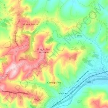
Name: Castelplanio topographic map, elevation, terrain.

Location: Castelplanio, Ancona, Marche, 60031, Italy (43.47846 13.06671 43.54014 13.14943)

Average elevation: 248 m

Minimum elevation: 101 m

Maximum elevation: 456 m

Other topographic maps

Click on a map to view its topography, its elevation and its terrain.

Montignano-Marzocca

Italy > Marche > Ancona > Senigallia

Average elevation: 26 m

Gear up for your next adventure:

🥤Collapsible Travel Cup - Saves space and weight in your mess kit
🏃Hydration Running Vest - Carry water and maps close to your body for speed
🥾Mountain Hiking Shoes - Shoes with superior grip for mountainous terrain
🗺️Topographic Maps - Detailed maps to explore trails, mountains, and wilderness areas
💧Hydration Pack - Hands-free hydration system for long hikes

As an Amazon Associate, this site earns from qualifying purchases at no extra cost to you.