Geolocate

Roscoe topographic map

Click on the map to display elevation.

About this map

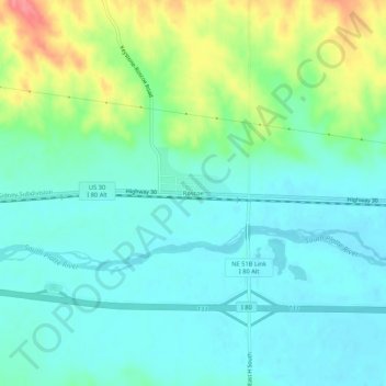
Name: Roscoe topographic map, elevation, terrain.

Location: Roscoe, Keith County, Nebraska, United States (41.10989 -101.60450 41.14989 -101.56450)

Average elevation: 977 m

Minimum elevation: 955 m

Maximum elevation: 1,035 m

Other topographic maps

Click on a map to view its topography, its elevation and its terrain.

Lake McConaughy

United States > Nebraska > Keith County

Average elevation: 1,048 m

Brule

United States > Nebraska > Keith County

Average elevation: 1,008 m

Gear up for your next adventure:

🧦Merino Wool Socks - Moisture-wicking comfort for long-distance hiking
🐕Hiking Dog Pack - Let your canine companion carry their own water and food
🧊Insulated Water Bottle - Keeps drinks cold in summer and prevents freezing in winter
🎒Hiking Backpack - Lightweight and ergonomic backpacks for day hikes or multi-day treks
🥾Trail Hiking Shoes - Durable shoes designed for rugged trails

As an Amazon Associate, this site earns from qualifying purchases at no extra cost to you.