
Make a donation
Gear up for your next adventure:
As an Amazon Associate, this site earns from qualifying purchases at no extra cost to you.
Engabao topographic map
Click on the map to display elevation.
Make a donation
Gear up for your next adventure:
As an Amazon Associate, this site earns from qualifying purchases at no extra cost to you.
About this map
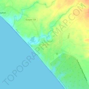
Name: Engabao topographic map, elevation, terrain.
Location: Engabao, General Villamil Playas, Playas, Guayas, Ecuador (-2.59290 -80.50867 -2.55290 -80.46867)
Average elevation: 13 m
Minimum elevation: 0 m
Maximum elevation: 35 m
Make a donation
Gear up for your next adventure:
As an Amazon Associate, this site earns from qualifying purchases at no extra cost to you.
Other topographic maps
Click on a map to view its topography, its elevation and its terrain.
Playas
Ecuador > Guayas > Playas > General Villamil Playas
General Villamil, también conocida como Playas, es una ciudad ecuatoriana; cabecera cantonal del Cantón Playas, así como la sexta urbe más grande y poblada de la Provincia de Guayas. Se localiza al sur de la región litoral del Ecuador, en una extensa llanura a orillas del océano Pacífico, a una altitud…
Average elevation: 7 m