
Make a donation
Gear up for your next adventure:
As an Amazon Associate, this site earns from qualifying purchases at no extra cost to you.
Pomponne topographic map
Click on the map to display elevation.
Make a donation
Gear up for your next adventure:
As an Amazon Associate, this site earns from qualifying purchases at no extra cost to you.
Pomponne
L'altitude varie de 37 mètres à 120 mètres pour le point le plus haut, le centre du bourg se situant à environ 46 mètres d'altitude (mairie).
Make a donation
Gear up for your next adventure:
As an Amazon Associate, this site earns from qualifying purchases at no extra cost to you.
About this map
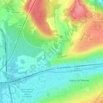
Name: Pomponne topographic map, elevation, terrain.
Average elevation: 72 m
Minimum elevation: 37 m
Maximum elevation: 128 m
Make a donation
Gear up for your next adventure:
As an Amazon Associate, this site earns from qualifying purchases at no extra cost to you.
Other topographic maps
Click on a map to view its topography, its elevation and its terrain.
Parc de l'Abbaye du Lys
France > Île-de-France > Seine-et-Marne > Dammarie-les-Lys
Average elevation: 66 m
Make a donation
Gear up for your next adventure:
As an Amazon Associate, this site earns from qualifying purchases at no extra cost to you.