
Make a donation
Gear up for your next adventure:
As an Amazon Associate, this site earns from qualifying purchases at no extra cost to you.
Knoblauchsberg topographic map
Click on the map to display elevation.
Make a donation
Gear up for your next adventure:
As an Amazon Associate, this site earns from qualifying purchases at no extra cost to you.
About this map
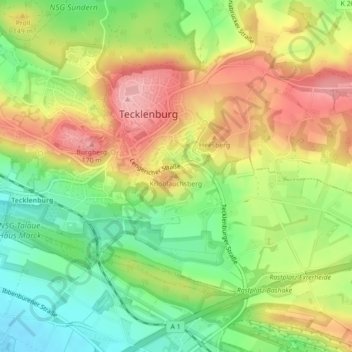
Name: Knoblauchsberg topographic map, elevation, terrain.
Average elevation: 131 m
Minimum elevation: 66 m
Maximum elevation: 202 m
Make a donation
Gear up for your next adventure:
As an Amazon Associate, this site earns from qualifying purchases at no extra cost to you.
Other topographic maps
Click on a map to view its topography, its elevation and its terrain.
Brochterbecker Schlucht
Deutschland > Nordrhein-Westfalen > Kreis Steinfurt > Tecklenburg > Brochterbeck
Average elevation: 97 m
Osterklee
Deutschland > Nordrhein-Westfalen > Kreis Steinfurt > Tecklenburg > Brochterbeck
Osterklee ist ein Naturschutzgebiet an der Grenze zwischen der Münsterländischen Tieflandsbucht und dem Weserbergland. Es erstreckt sich über 40 Hektar, etwa einen Kilometer östlich von Brochterbeck auf dem exponierten Kleeberg. Die exakte geographische Position ist 52° 13,75" nördliche Breite, 7°…
Average elevation: 87 m