
Make a donation
Gear up for your next adventure:
As an Amazon Associate, this site earns from qualifying purchases at no extra cost to you.
Mels topographic map
Click on the map to display elevation.
Make a donation
Gear up for your next adventure:
As an Amazon Associate, this site earns from qualifying purchases at no extra cost to you.
Mels
Der Turnverein Mels ist mehrfacher Schweizermeister in den Disziplinen Barren- und Bodenturnen. 1993 wurde die humoristische Akrobatiktruppe D’Holmikers gegründet, die seither an unzähligen internationalen Shows teilgenommen hat. Als Höhepunkt gilt der Gewinn des «bronzenen Clowns» anlässlich des 41. internationalen Zirkusfestivals von Monte Carlo.
Make a donation
Gear up for your next adventure:
As an Amazon Associate, this site earns from qualifying purchases at no extra cost to you.
About this map
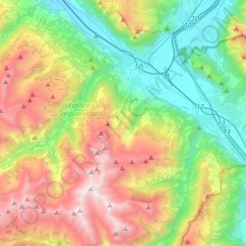
Name: Mels topographic map, elevation, terrain.
Location: Mels, Wahlkreis Sarganserland, St. Gallen, 8887, Schweiz (46.92702 9.23628 47.08138 9.48523)
Average elevation: 1,317 m
Minimum elevation: 442 m
Maximum elevation: 2,801 m
Make a donation
Gear up for your next adventure:
As an Amazon Associate, this site earns from qualifying purchases at no extra cost to you.
Other topographic maps
Click on a map to view its topography, its elevation and its terrain.
Make a donation
Gear up for your next adventure:
As an Amazon Associate, this site earns from qualifying purchases at no extra cost to you.
Schwendi im Weisstannental
Schweiz > St. Gallen > Wahlkreis Sarganserland > Mels
Average elevation: 1,441 m
Make a donation
Gear up for your next adventure:
As an Amazon Associate, this site earns from qualifying purchases at no extra cost to you.
Make a donation
Gear up for your next adventure:
As an Amazon Associate, this site earns from qualifying purchases at no extra cost to you.