
Make a donation
Gear up for your next adventure:
As an Amazon Associate, this site earns from qualifying purchases at no extra cost to you.
Göggingen topographic map
Click on the map to display elevation.
Make a donation
Gear up for your next adventure:
As an Amazon Associate, this site earns from qualifying purchases at no extra cost to you.
About this map
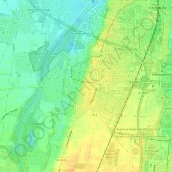
Name: Göggingen topographic map, elevation, terrain.
Location: Göggingen, Augsburg, Bayern, 86199, Deutschland (48.31906 10.83438 48.35508 10.88949)
Average elevation: 496 m
Minimum elevation: 481 m
Maximum elevation: 510 m
Make a donation
Gear up for your next adventure:
As an Amazon Associate, this site earns from qualifying purchases at no extra cost to you.
Other topographic maps
Click on a map to view its topography, its elevation and its terrain.
Wittelsbacher Park
Deutschland > Bayern > Augsburg
Die engen und teilweise nur 1,40 Meter hohen Gänge wurden in sehr kurzer Zeit angelegt, um den dagebliebenen Bürgern schnell Schutz bieten zu können. Der größte Raum bietet gerade Stehhöhe und fasst nur 15 Personen.
Average elevation: 491 m