
Make a donation
Gear up for your next adventure:
As an Amazon Associate, this site earns from qualifying purchases at no extra cost to you.
Greenland topographic map
Click on the map to display elevation.
Make a donation
Gear up for your next adventure:
As an Amazon Associate, this site earns from qualifying purchases at no extra cost to you.
Greenland
The lowest temperature ever recorded in the Northern Hemisphere was recorded in Greenland, near the topographic summit of the Greenland Ice Sheet, on 22 December 1991, when the temperature reached −69.6 °C (−93.3 °F). In Nuuk, the average daily temperature varies over the seasons from −5.1 to 9.9 °C (22.8 to 49.8 °F). The total area of Greenland is 2,166,086 km2 (836,330 sq mi) (including other offshore minor islands), of which the Greenland ice sheet covers 1,755,637 km2 (677,855 sq mi) (81%) and has a volume of approximately 2,850,000 km3 (680,000 cu mi). The highest point on Greenland is Gunnbjørn Fjeld at 3,700 m (12,100 ft) of the Watkins Range (East Greenland mountain range). The majority of Greenland, however, is less than 1,500 m (4,900 ft) in elevation.
Make a donation
Gear up for your next adventure:
As an Amazon Associate, this site earns from qualifying purchases at no extra cost to you.
About this map
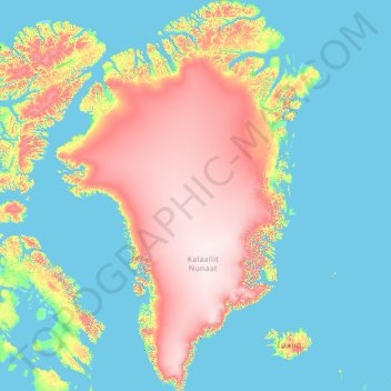
Name: Greenland topographic map, elevation, terrain.
Location: Greenland (59.97372 -73.02632 83.66085 -11.35111)
Average elevation: 627 m
Minimum elevation: -2 m
Maximum elevation: 3,522 m
Make a donation
Gear up for your next adventure:
As an Amazon Associate, this site earns from qualifying purchases at no extra cost to you.
Other topographic maps
Click on a map to view its topography, its elevation and its terrain.