Geolocate

Moiben topographic map

Click on the map to display elevation.

About this map

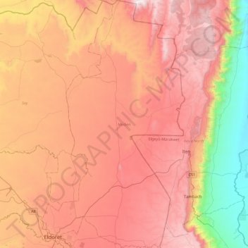
Name: Moiben topographic map, elevation, terrain.

Location: Moiben, Uasin Gishu County, Rift Valley, 30100, Kenya (0.49982 35.25249 0.94350 35.50751)

Average elevation: 2,000 m

Minimum elevation: 1,035 m

Maximum elevation: 2,734 m

Gear up for your next adventure:

🥾Trail Running Boots - Durable shoes designed for trail running
🔋Emergency Crank Radio - Weather alerts and power without needing batteries
🧭GPS Handheld Device - Reliable GPS navigation for outdoor adventures
🧢Hiking Hat - Sun-protective and breathable hats for long treks
🥾Durable Hiking Shoes - Long-lasting shoes for frequent hiking

As an Amazon Associate, this site earns from qualifying purchases at no extra cost to you.