Geolocate

Stage Junction topographic map

Click on the map to display elevation.

About this map

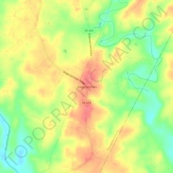
Name: Stage Junction topographic map, elevation, terrain.

Location: Stage Junction, Fluvanna County, Virginia, United States (37.77098 -78.17333 37.81098 -78.13333)

Average elevation: 96 m

Minimum elevation: 56 m

Maximum elevation: 131 m

Other topographic maps

Click on a map to view its topography, its elevation and its terrain.

Columbia

United States > Virginia > Fluvanna County

Average elevation: 78 m

Gear up for your next adventure:

🥾Trail Running Boots - Durable shoes designed for trail running
🦶Hiking Shoe Insoles - Added support for high arches and long days on feet
🧭Orienteering Kit - Tools for map reading and navigation in the wild
🔋Emergency Crank Radio - Weather alerts and power without needing batteries
Camping Essentials - All-in-one gear for a comfortable camping trip

As an Amazon Associate, this site earns from qualifying purchases at no extra cost to you.