
Pinhão topographic map
Interactive map
Click on the map to display elevation.
About this map
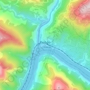
Name: Pinhão topographic map, elevation, terrain.
Location: Pinhão, Alijó, Vila Real, Portugal (41.17967 -7.54871 41.20073 -7.51570)
Average elevation: 217 m
Minimum elevation: 77 m
Maximum elevation: 506 m
Other topographic maps
Click on a map to view its topography, its elevation and its terrain.
Tourém
Portugal > Vila Real > Montalegre
Tourém, Montalegre, Vila Real, Portugal
Average elevation: 1,026 m
Castanheiro
Portugal > Vila Real > Montalegre
Castanheiro, Montalegre, Vila Real, Portugal
Average elevation: 1,082 m
Covas do Barroso
Portugal > Vila Real > Boticas
Covas do Barroso, Boticas, Vila Real, Portugal
Average elevation: 644 m
Bragado
Portugal > Vila Real > Vila Pouca de Aguiar
Bragado, Vila Pouca de Aguiar, Vila Real, Portugal
Average elevation: 628 m
Vidago (União das freguesias de Vidago, Arcossó, Selhariz e Vilarinho das Paranheiras)
Vidago (União das freguesias de Vidago, Arcossó, Selhariz e Vilarinho das Paranheiras), Chaves, Vila Real, Portugal
Average elevation: 444 m
Casas Novas
Portugal > Vila Real > Chaves > Redondelo
Casas Novas, Redondelo, Chaves, Vila Real, 5400-727, Portugal
Average elevation: 494 m
Rio Rabagão
Portugal > Vila Real > Montalegre > Chã
Rio Rabagão, Chã, Montalegre, Vila Real, 5470-071, Portugal
Average elevation: 898 m