
Kaituna River topographic map
Interactive map
Click on the map to display elevation.
About this map
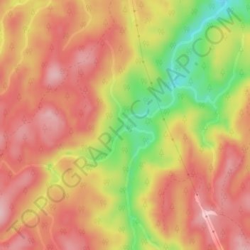
Name: Kaituna River topographic map, elevation, terrain.
Average elevation: 228 m
Minimum elevation: 108 m
Maximum elevation: 298 m
Other topographic maps
Click on a map to view its topography, its elevation and its terrain.
Waipa Stream
New Zealand > Bay of Plenty > Rotorua
Waipa Stream, Tihiotonga, Rotorua, Bay of Plenty, 3010, New Zealand
Average elevation: 343 m
Lake Rerewhakaaitu
New Zealand > Bay of Plenty > Rotorua
Lake Rerewhakaaitu, Rotorua, Bay of Plenty, New Zealand
Average elevation: 440 m
Waikuta
New Zealand > Bay of Plenty > Rotorua > Ngongotaha > Waikuta
Waikuta, Ngongotaha, Rotorua, Bay of Plenty, 3015, New Zealand
Average elevation: 324 m
Mokoia Island
New Zealand > Bay of Plenty > Rotorua
Mokoia Island, Rotorua, Rotorua District, Bay of Plenty, New Zealand
Average elevation: 291 m
Mount Tarawera
New Zealand > Bay of Plenty > Rotorua
Mount Tarawera, Rotorua, Rotorua District, Bay of Plenty, New Zealand
Average elevation: 894 m
Tarawera River
New Zealand > Bay of Plenty > Rotorua
Tarawera River, Rotorua, Rotorua District, Bay of Plenty, New Zealand
Average elevation: 194 m
Lake Rotongata
New Zealand > Bay of Plenty > Rotorua
Lake Rotongata, Kaharoa Road, Rotorua, Rotorua District, Bay of Plenty, 3096, New Zealand
Average elevation: 340 m
Okere Falls
New Zealand > Bay of Plenty > Rotorua
Okere Falls, Rotorua, Rotorua District, Bay of Plenty, New Zealand
Average elevation: 315 m
Lake Rotokawa
New Zealand > Bay of Plenty > Rotorua
Lake Rotokawa, Te Huaki Crescent, Eastgate Business Park, Hannahs Bay, Rotorua, Rotorua District, Bay of Plenty, 3042, New Zealand
Average elevation: 306 m