Geolocate

Susa topographic map

Click on the map to display elevation.

About this map

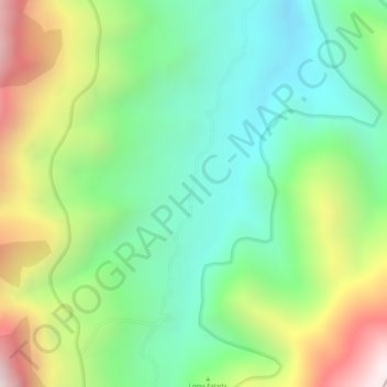
Name: Susa topographic map, elevation, terrain.

Location: Susa, Onzaga, Santander, RAP Gran Santander, Colombia (6.18543 -72.84245 6.20543 -72.82245)

Average elevation: 3,024 m

Minimum elevation: 2,716 m

Maximum elevation: 3,513 m

Other topographic maps

Click on a map to view its topography, its elevation and its terrain.

Padua

Colombia > Santander > Onzaga

Average elevation: 1,928 m

Gear up for your next adventure:

🥾Trail Hiking Boots - Supportive boots for rough trails
🥾Light Trekking Boots - Supportive boots for multi-day treks
🥾Hiking Shoes - Durable and comfortable shoes for trail hiking
🥾Trekking Boots - Durable boots for long-distance trekking
🥾Trail Hiking Socks - Comfortable socks to prevent blisters and fatigue

As an Amazon Associate, this site earns from qualifying purchases at no extra cost to you.