Geolocate

Dumbría topographic map

Click on the map to display elevation.

About this map

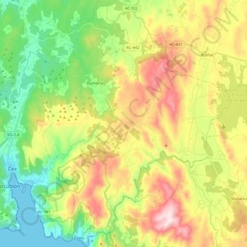
Name: Dumbría topographic map, elevation, terrain.

Location: Dumbría, Fisterra, A Coruña, Galicia, Spain (42.90538 -9.18278 43.06312 -8.99879)

Average elevation: 233 m

Minimum elevation: 0 m

Maximum elevation: 638 m

Other topographic maps

Click on a map to view its topography, its elevation and its terrain.

Lires

Spain > Galicia > Fisterra > Cee

Average elevation: 63 m

Fisterra

Spain > Galicia > Fisterra

Average elevation: 20 m

Gear up for your next adventure:

🔦LED Headlamp - Hands-free lighting for early morning starts or late finishes
Lightweight Backpacking Tent - Compact tent for efficient hiking trips
🚲Bike Repair Kit - Essential tools for on-trail mechanical issues
🚑Survival Whistle - Signal for help across long distances in mountains
🧭GPS Outdoor Watch - Smart watch for navigation and fitness tracking in nature

As an Amazon Associate, this site earns from qualifying purchases at no extra cost to you.