Geolocate

Fisterra topographic map

Click on the map to display elevation.

About this map

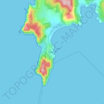
Name: Fisterra topographic map, elevation, terrain.

Location: Fisterra, A Coruña, Galicia, 45155, Spain (42.86648 -9.30379 42.94648 -9.22379)

Average elevation: 20 m

Minimum elevation: -1 m

Maximum elevation: 241 m

Other topographic maps

Click on a map to view its topography, its elevation and its terrain.

Fisterra

Spain > Galicia > Fisterra

Average elevation: 38 m

Muxía

Spain > Galicia > Fisterra

Average elevation: 71 m

Dumbría

Spain > Galicia > Fisterra

Average elevation: 233 m

Gear up for your next adventure:

💡LED Headlamp - Hands-free illumination for night hiking and camping
🧰Multitool Knife - Compact and versatile tool for outdoor use
🧥Waterproof Hiking Jacket - Protect yourself from rain and wind while hiking
🔭Compact Binoculars - Lightweight optics for scouting trails and wildlife
🔋Lithium AA Batteries - Long-lasting power that performs in extreme cold

As an Amazon Associate, this site earns from qualifying purchases at no extra cost to you.