Geolocate

Cogon topographic map

Click on the map to display elevation.

About this map

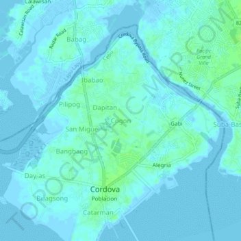
Name: Cogon topographic map, elevation, terrain.

Location: Cogon, Cordova, Cebu, Central Visayas, 6017, Philippines (10.24399 123.93227 10.28399 123.97227)

Average elevation: 2 m

Minimum elevation: -2 m

Maximum elevation: 9 m

Other topographic maps

Click on a map to view its topography, its elevation and its terrain.

Nalusuan Island

Philippines > Cebu > Cordova > Gilutongan

Average elevation: 0 m

Gear up for your next adventure:

🥾Approach Boots - Comfortable boots for hiking and climbing approaches
🧴First Aid Kit - Essential first aid supplies for outdoor emergencies
🩹Compact First Aid Kit - Pre-packed essentials for common trail injuries
🦶Hiking Shoe Insoles - Added support for high arches and long days on feet
🧶550 Survival Paracord - Versatile utility cord for emergency repairs and rigging

As an Amazon Associate, this site earns from qualifying purchases at no extra cost to you.