Geolocate

Eden topographic map

Click on the map to display elevation.

About this map

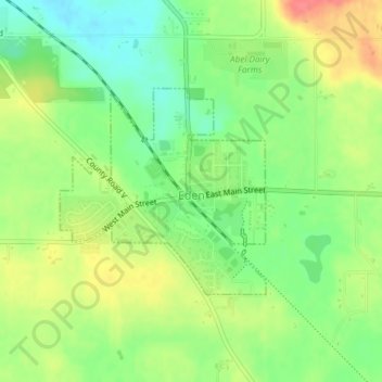
Name: Eden topographic map, elevation, terrain.

Location: Eden, Fond du Lac County, Wisconsin, United States (43.68567 -88.37572 43.70024 -88.35560)

Average elevation: 317 m

Minimum elevation: 287 m

Maximum elevation: 353 m

Other topographic maps

Click on a map to view its topography, its elevation and its terrain.

Waucousta

United States > Wisconsin > Fond du Lac County

Average elevation: 316 m

Eldorado

United States > Wisconsin > Fond du Lac County

Average elevation: 267 m

Gear up for your next adventure:

🥾Lightweight Hiking Shoes - Comfortable shoes for day hikes
🥾Trail Running Boots - Durable shoes designed for trail running
👟Trail Running Shoes - Agile footwear for fast-paced topographic exploration
🧢Hiking Hat - Sun-protective and breathable hats for long treks
🥾Hiking Boots - Sturdy boots providing ankle support and traction on rugged trails

As an Amazon Associate, this site earns from qualifying purchases at no extra cost to you.