
Thank you for supporting this site ❤️
Make a donation
Make a donation
Gear up for your next adventure:
As an Amazon Associate, this site earns from qualifying purchases at no extra cost to you.
Alt Wallmoden topographic map
Click on the map to display elevation.
Thank you for supporting this site ❤️
Make a donation
Make a donation
Gear up for your next adventure:
As an Amazon Associate, this site earns from qualifying purchases at no extra cost to you.
About this map
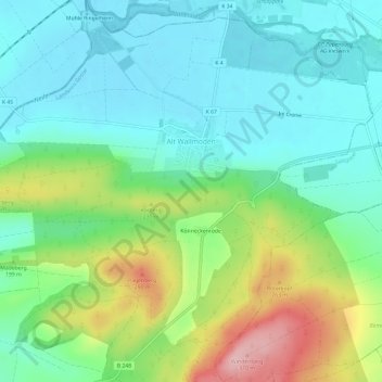
Name: Alt Wallmoden topographic map, elevation, terrain.
Average elevation: 177 m
Minimum elevation: 123 m
Maximum elevation: 307 m
Thank you for supporting this site ❤️
Make a donation
Make a donation
Gear up for your next adventure:
As an Amazon Associate, this site earns from qualifying purchases at no extra cost to you.
Other topographic maps
Click on a map to view its topography, its elevation and its terrain.
Ostlutter
Deutschland > Niedersachsen > Landkreis Goslar > Langelsheim
Der Ort liegt am südwestlichen Ende des bewaldeten Höhenzugs Wahrenberg, einem Teil des Innersteberglands.
Average elevation: 210 m