
Ar Rass topographic map
Interactive map
Click on the map to display elevation.
About this map
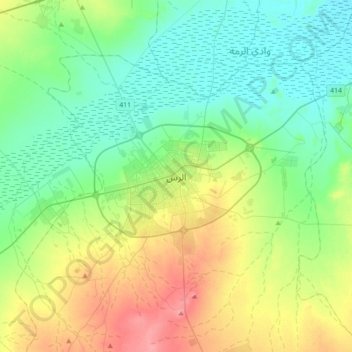
Name: Ar Rass topographic map, elevation, terrain.
Location: Ar Rass, محافظة الرس, Al Qasim, 58893, Arabie saoudite (25.70852 43.34390 26.02852 43.66390)
Average elevation: 685 m
Minimum elevation: 647 m
Maximum elevation: 775 m
Other topographic maps
Click on a map to view its topography, its elevation and its terrain.
محافظة رياض الخبراء
محافظة رياض الخبراء, Al Qasim, Arabie saoudite
Average elevation: 886 m
Buraydah
Arabie saoudite > Al Qasim > Buraydah
Buraydah, محافظة بريدة, Al Qasim, 52354, Arabie saoudite
Average elevation: 628 m