
Thank you for supporting this site ❤️
Make a donation
Make a donation
Gear up for your next adventure:
As an Amazon Associate, this site earns from qualifying purchases at no extra cost to you.
LLimancay topographic map
Click on the map to display elevation.
Thank you for supporting this site ❤️
Make a donation
Make a donation
Gear up for your next adventure:
As an Amazon Associate, this site earns from qualifying purchases at no extra cost to you.
About this map
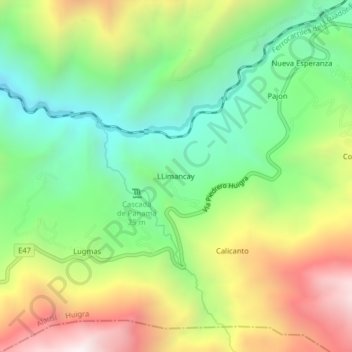
Name: LLimancay topographic map, elevation, terrain.
Location: LLimancay, Huigra, Alausí, Chimborazo, Ecuador (-2.33470 -79.02927 -2.29470 -78.98927)
Average elevation: 1,511 m
Minimum elevation: 939 m
Maximum elevation: 2,350 m
Thank you for supporting this site ❤️
Make a donation
Make a donation
Gear up for your next adventure:
As an Amazon Associate, this site earns from qualifying purchases at no extra cost to you.