
Nashville-Davidson topographic map
Interactive map
Click on the map to display elevation.
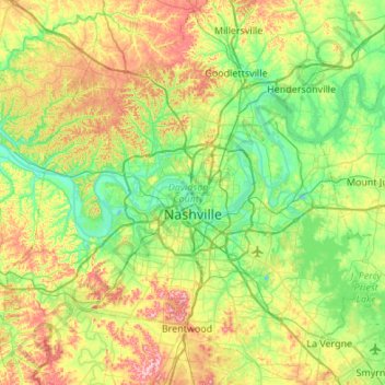
Nashville-Davidson topographic map, elevation, terrain
Nashville-Davidson
Nashville lies on the Cumberland River in the northwestern portion of the Nashville Basin. Nashville's elevation ranges from its lowest point, 385 feet (117 m) above sea level at the Cumberland River, to its highest point, 1,163 feet (354 m) above sea level in the Radnor Lake State Natural Area. Nashville also sits at the start of the Highland Rim, a geophysical region of very hilly land. Because of this, Nashville is very hilly. Nashville also has some stand alone hills around the city such as the hill on which the Tennessee State Capitol building sits. According to the United States Census Bureau, the city has a total area of 527.9 square miles (1,367 km2), of which 504.0 square miles (1,305 km2) of it is land and 23.9 square miles (62 km2) of it (4.53%) is water.
About this map
Name: Nashville-Davidson topographic map, elevation, terrain.
Average elevation: 184 m
Minimum elevation: 109 m
Maximum elevation: 344 m
Other topographic maps
Click on a map to view its topography, its elevation and its terrain.
J. Percy Priest Lake
United States > Tennessee > Davidson County > Nashville-Davidson
Average elevation: 169 m
Antioch
United States > Tennessee > Davidson County > Nashville-Davidson > Antioch
Average elevation: 175 m
Forest Hills
United States > Tennessee > Davidson County
In addition to these two branches of the Natchez Trace, a third route led from Franklin to Nashville along what was historically known as the Middle Franklin Turnpike. This branch of the Natchez Trace left the main road at Leiper's Fork in Williamson County and extended east to Franklin. From Franklin, this…
Average elevation: 218 m