
Sunset Beach topographic map
Click on the map to display elevation.
About this map
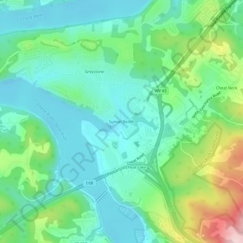
Name: Sunset Beach topographic map, elevation, terrain.
Average elevation: 331 m
Minimum elevation: 258 m
Maximum elevation: 529 m
Other topographic maps
Click on a map to view its topography, its elevation and its terrain.
Morgantown
United States > West Virginia > Monongalia County
During the 1970s, the U.S. Department of Transportation built an experimental driverless personal rapid transit system in the city, citing the area's variable seasonal climate and geographic elevations as factors in testing the technology's viability. The Morgantown Personal Rapid Transit (PRT) has been in use…
Average elevation: 337 m