Geolocate

Angola topographic map

Click on the map to display elevation.

About this map

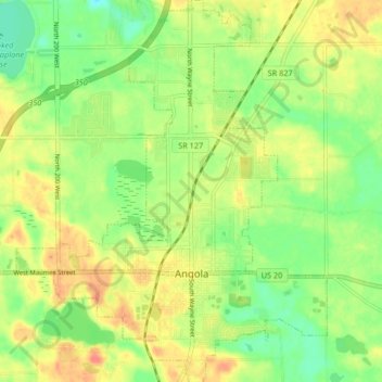
Name: Angola topographic map, elevation, terrain.

Location: Angola, Steuben County, Indiana, United States (41.61720 -85.03736 41.67915 -84.96990)

Average elevation: 315 m

Minimum elevation: 290 m

Maximum elevation: 342 m

Other topographic maps

Click on a map to view its topography, its elevation and its terrain.

Pleasant Lake

United States > Indiana > Steuben County

Average elevation: 297 m

Moonlight

United States > Indiana > Steuben County

Average elevation: 297 m

Lake James

United States > Indiana > Steuben County

Average elevation: 303 m

Circle Park

United States > Indiana > Steuben County > Hamilton

Average elevation: 284 m

Gear up for your next adventure:

Camping Tent - Weather-resistant tents suitable for 2 to 6 people
💡Solar Camping Lamp - Eco-friendly lighting for campsites
Camping Groundsheet - Protect your tent from moisture and dirt
🥾Mountaineering Boots - Supportive boots for climbing and high-altitude hiking
🧢Beanie Hat - Keep your head warm in cold weather

As an Amazon Associate, this site earns from qualifying purchases at no extra cost to you.