
Make a donation
Gear up for your next adventure:
As an Amazon Associate, this site earns from qualifying purchases at no extra cost to you.
Kladovo Municipality topographic map
Click on the map to display elevation.
Make a donation
Gear up for your next adventure:
As an Amazon Associate, this site earns from qualifying purchases at no extra cost to you.
About this map
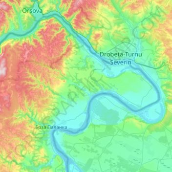
Name: Kladovo Municipality topographic map, elevation, terrain.
Average elevation: 189 m
Minimum elevation: 35 m
Maximum elevation: 680 m
Make a donation
Gear up for your next adventure:
As an Amazon Associate, this site earns from qualifying purchases at no extra cost to you.
Other topographic maps
Click on a map to view its topography, its elevation and its terrain.
Negotin
Serbia > Central Serbia > Bor Administrative District > Negotin Municipality
Average elevation: 86 m
Stol
Serbia > Central Serbia > Bor Administrative District > Bucje
Stol (Serbian Cyrillic: Стол) is a mountain in eastern Serbia, near the town of Bor. Its highest peak has an elevation of 1,156 meters above sea level. Like nearby Veliki Krš and Mali Krš, Stol has a number of pronounced karst formations. There is a mountain hut with around 35 beds, maintained by the…
Average elevation: 805 m
Bor
Serbia > Central Serbia > Bor Administrative District
Crni Vrh is a mountain 30 km from the city center. Highest peak has an elevation of 1,043 m (3,422 ft) above sea level. It has several ski tracks anda ski lift. The main ski track is 1,100 m long and has height span of 260 m. Just 16 km from the city center there is another mountain Stol. Its highest peak has…
Average elevation: 474 m
Rajac
Serbia > Central Serbia > Bor Administrative District > Negotin Municipality
Average elevation: 127 m
Make a donation
Gear up for your next adventure:
As an Amazon Associate, this site earns from qualifying purchases at no extra cost to you.
Prahovo
Serbia > Central Serbia > Bor Administrative District > Negotin Municipality
Average elevation: 48 m