
Make a donation
Gear up for your next adventure:
As an Amazon Associate, this site earns from qualifying purchases at no extra cost to you.
Vallery topographic map
Click on the map to display elevation.
Make a donation
Gear up for your next adventure:
As an Amazon Associate, this site earns from qualifying purchases at no extra cost to you.
Vallery
Vallery, commune d'environ 500 habitants, est située au nord-ouest du département de l'Yonne, dans le Gâtinais et la vallée de l'Orvanne. Elle est limitrophe de la région Île-de-France. Son altitude est comprise entre 120 et 160 mètres.
Make a donation
Gear up for your next adventure:
As an Amazon Associate, this site earns from qualifying purchases at no extra cost to you.
About this map
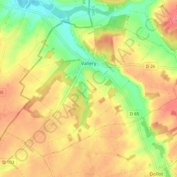
Name: Vallery topographic map, elevation, terrain.
Average elevation: 142 m
Minimum elevation: 105 m
Maximum elevation: 171 m
Make a donation
Gear up for your next adventure:
As an Amazon Associate, this site earns from qualifying purchases at no extra cost to you.
Other topographic maps
Click on a map to view its topography, its elevation and its terrain.
Make a donation
Gear up for your next adventure:
As an Amazon Associate, this site earns from qualifying purchases at no extra cost to you.
Les miniers
France > Bourgogne-Franche-Comté > Yonne > Charny Orée de Puisaye
Average elevation: 180 m
La Levée
France > Bourgogne-Franche-Comté > Yonne > Saint-Maurice-Thizouaille
Average elevation: 151 m
Make a donation
Gear up for your next adventure:
As an Amazon Associate, this site earns from qualifying purchases at no extra cost to you.